Road transportation to and from Mahdia in Region Eight began to return to normal yesterday, as water from the nearby Hand Rail Creek that overtopped over the weekend receded.
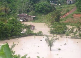
Residents in the area told Stabroek News yesterday that the many homes which were affected by the flood waters had to be cleaned of thick slush. While the area, low-lying parts in particular, is usually affected by heavy rainfall, residents yesterday said that the maintenance of tailings pond in the White Hole area was partly to be blame for the weekend flooding. Persons said the boundaries of a few tailing ponds in the area were broken, resulting in additional water accumulating in the nearby Hand Rail Creek, which passes through the community.
The Guyana Geology and Mines Commission (GGMC) aided by the Guyana Environmental and Capacity Building Development Project (GENCAPB) had undertaken pilot projects to confine water utilised by open-pit mining operations to the tailing ponds. The mining operators were expected to utilise similar ponds for their operations but several operators who spoke to this newspaper last year said the project was expensive for each mining operator to implement.
Regional Chairman Senor Bell told this newspaper on Sunday that the region was prone to flooding during the rainy season and he noted that economic activities, such as mining and farming, were usually affected as a result. Bell stated that current rainy season began in April and may run into July. He said that water accumulated at flooded areas around Mahdia would normally recede after several hours, providing the rain eases.
He said the accumulated water is usually drained out of the area through the Kangaruma Falls, a tributary of the Potaro River.
Bell and Regional Executive Officer Ishwar Dass told this newspaper on Sunday that there was no reason to be alarmed where the human factor is concerned, as the population of approximately 10,000 is scattered. Dass noted that the farming areas in the North Pakaraimas are normally affected by continuous rains.
Meanwhile, transportation along the trail, which connects Mahdia with the coastland, continues to be hampered by high levels of water in the Essequibo River. Residents in the area said minibuses plying the route between Georgetown and Mahdia were transporting passengers to and from both locations to Mango Landing, on the Essequibo River where boats are being used in lieu of the pontoon service offered by the Mekdeci Mining Company.
