-menaces US
HAVANA, (Reuters) – Hurricane Sandy swelled into a major threat to much of the U.S. East Coast yesterday, U.S. forecasters said, as the storm swirled through the Bahamas after killing 21 people across the Caribbean.
Strengthening rapidly after tearing into Jamaica and crossing the warm Caribbean Sea, Sandy hit southeastern Cuba early yesterday with top sustained winds up to 110 miles per hour (177 km per hour) that left a trail of destruction, especially in the historic city of Santiago de Cuba.
The Cuban government said last night that 11 people died in the storm, most killed by falling trees or in building collapses, including nine in Santiago de Cuba province and two in neighbouring Guantanamo province.
Haiti’s civil protection office said nine people had died despite not getting a direct hit from Sandy, and one person was killed by falling rocks in Jamaica when the storm struck there on Wednesday.
The Cuban deaths were an unusually high number for the communist island that prides itself on protecting its people from storms by ordering mass evacuations.
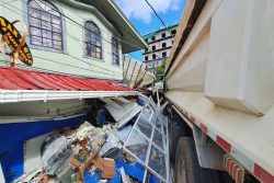
Images on Cuban television showed downed trees, damaged buildings and debris-clogged streets in the country’s second-largest city of Santiago de Cuba, which suffered a direct hit when the storm came ashore in the early morning hours.
“Everything’s destroyed in Santiago. People are going to have to work very hard to recover,” Alexis Manduley, a resident of the 498-year-old city, told Reuters by telephone. Santiago de Cuba, with a population of about 500,000, is 470 miles (750 km) southeast of Havana.
NEXT STOP: US
EAST COAST
U.S. government forecasters warned that much of the U.S. East Coast could get swiped by Sandy, with flooding, heavy rains and high winds beginning late yesterday in Florida. By early next week – amid final preparations for the crucial Nov. 6 presidential election – the storm could hit an area of New England where Hurricane Irene caused severe damage last year.
White House spokesman Jay Carney declined to speculate about whether there would be any change in President Barack Obama’s campaign travel schedule because of Sandy, as he makes a last-minute blitz to win an edge over Republican Mitt Romney in a close race.
“The president’s concern about this storm is to make sure that citizens in potentially affected areas are aware of this and taking necessary precaution,” Carney said.
He spoke aboard Air Force One as Obama headed from Florida to Virginia, saying the president had asked his team to hold regular briefings with federal disaster officials as the storm progresses.
Sandy is forecast to make landfall as a Category 1 hurricane and the hardest-hit areas could span anywhere from the coastal Carolinas up to Maine, with New York City and the Boston area potentially in harm’s way. “Regardless of the exact track of Sandy, it is likely that significant impacts will be felt over portions of the U.S. East Coast through the weekend and into early next week,” the Miami-based U.S. National Hurricane Center said.
‘FRANKENSTORM’
“It’s going to be a high-impact event,” said Bob Oravec, a lead forecaster with the National Oceanic and Atmospheric Administra-tion’s HydroMeteorological Prediction Center in College Park, Maryland.
“It has the potential to be a very significant storm with respect to coastal flooding, depending on exactly where it comes in. Power outages are definitely a big threat,” he said. In a subsequent report, NOAA’s storm-prediction center suggested that Sandy could invite the ghoulish nickname “Frankenstorm,” due to upcoming celebrations of Halloween and some of the freakish characteristics of the storm.
The late-season cyclone is widely expected to undergo an unusual merger with a polar air mass over the Mid-Atlantic and Northeast on Tuesday, essentially bringing two sources of energy together and giving Sandy the potential to punch above its weight as it sloshes across the U.S. coast.
At 11 p.m. EDT (0300 GMT), the NHC said Sandy was about 15 miles (25 km) north-northeast of Eleuthera Island in the Bahamas and packing maximum sustained winds of 90 mph (150 kph).
High winds, rains and pounding surf are expected across parts of Florida’s Atlantic coast, with the biggest impact lasting through Friday. Orange juice prices rose in U.S. trading on Thursday on speculative buying as investors bet that Sandy could damage crops in the citrus-rich Sunshine State.
Unlike Irene, which caused billions of dollars in damage as it battered the Northeast in August last year, Sandy is forecast to be a weaker storm but will be moving slower than Irene, likely bringing more rain and increasing its potential for damage, weather forecasters said.
At $4.3 billion in losses, Irene ranks as one of the 10 costliest hurricanes, adjusted for inflation and excluding federally insured damage, according to the Insurance Information Institute, an industry group.
‘A BILLION-
DOLLAR DISASTER’
Jeff Masters, a hurricane specialist and blogger with private forecaster Weather Underground (www. wunderground.com), said a landfall by Sandy on Monday along the Mid-Atlantic Coast could trigger “a billion-dollar disaster.” “In this scenario, Sandy would be able to bring sustained winds near hurricane force over a wide stretch of heavily populated coast,” he said.
Alternately, Masters said, some computer forecast models indicated Sandy had the potential to unleash “the heaviest October rains ever reported in the northeast U.S., Nova Scotia and New Brunswick.” NOAA’s Oravec said there could be tropical-storm to hurricane-force winds on the coast and added: “Coastal flooding will be a big concern.”


