Four years after it was commissioned and innumerable bouts of severe weather later, the $550 million Doppler Radar project intended to provide up-to-the-minute weather reports isn’t doing so leaving some to conclude that the European Union and Guyana-funded project is a failure in that respect.
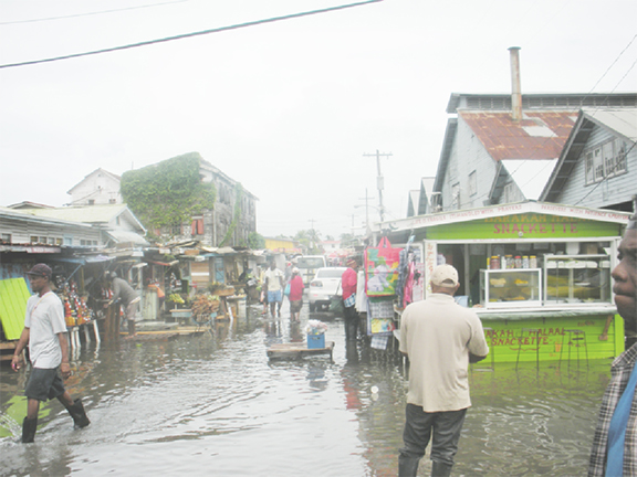
Commissioned since October 2009, the up-to-the minute aspect of the Doppler is yet to be utilized by various stakeholders. Severe weather warnings can give stakeholders valuable time to prepare as in the case of yesterday’s flash flooding. Yesterday’s heavy downpours caught tens of thousands of residents unawares.
Although the Doppler process is partially available via the HydroMet Services website, the vast majority of the Guyanese populace is not privy to what exactly the Doppler is reading. The website, www.hydromet.gov.gy, itself is complicated to navigate and seemingly requires some knowledge of how to read radar imaging, that is if the site decides to work. Sources say that this can be chalked up to the lack of professionals capable of reading the Doppler imaging correctly and producing a useful forum such as a properly functioning website to relay information in a clear manner.
Agriculture Minister Dr Leslie Ramsammy yesterday at a press engagement simply stated that to get the most from the current system “you need more money”. He said that the current systems including the Doppler Radar, while providing minute-to-minute information, more technology was required to deliver information. Ramsammy stated “unless you have other technology you need time” continuing that “what the Doppler has been placed there for is to say that presently in this environment where the airport is, because this is for airport visibility and telling where the airplanes what kind of weather we have.”
He stated that how the information is relayed, by the time the next reading is delivered it is null. He stated that in North America and other parts of the world aircraft are sent into the weather systems to measure other variances which would relay that information quicker. He noted that weather chasers do not exist in Guyana and as a result the Doppler can provide information, but by the time it is relayed the shift in weather patterns could be two or three hours’ difference. Stabroek News did inquire as to why even the few hours’ warning was not being provided to farmers and citizens.
Dr Ramsammy stated that measuring the direction of how fast the precipitation was moving was more important than measuring the precipitation itself in order to determine if the weather patterns would affect Guyana or not.
Dr Ramsammy did acknowledge that the Doppler system was “critical” to deciphering weather throughout Guyana and it was part of the daily weather forecast that is broadcast on NCN.
Dr Ramsammy steered away from the Doppler being a tool for citizens and focused on the aeronautical aspect, “the Doppler allows them to say at any one spot…it is more or an aeronautic tool because we need to allow the planes that are coming in and out how much rain is in that air at that particular time”. He said that the heavy rainfall which hit Regions 2, 3, 4, 5, 6, 7 and 10 yesterday was an unusual occurrence and was due to a high pressure system off Bermuda pushing the Inter-Tropical Convergence Zone closer to Guyana.
However it is the up-to-the-minute warning potential that the Doppler was supposed to have that seems to be absent from the HydroMet office which is responsible for relaying the information routinely.
He did note vehemently that the forecasts provided by HydroMet were not secret, however when Stabroek News visited the offices yesterday located at 18 Brickdam it was told that information could not be provided to media personnel but could be provided to ordinary members of the public. Officials at the office said that this publication would have to reach out to the Timehri office or the ministry. Previously Stabroek News had spoken with representatives at Timehri and was directed to the Chief Hydrometeorological Officer, Diane Misir, but has since been unsuccessful in speaking to her about the capacity and capabilities at HydroMet and in reading Doppler Radar.
Presented
The Doppler Radar was originally presented to Guyanese as a facility that would be able to give up to date weather coverage every 15 minutes. Then Agriculture Minister Robert Persaud had boasted that the Doppler system would be capable of displaying weather conditions recorder earlier and predictive data. Persaud had also noted at the commissioning that the system would feed into others from Suriname, Trinidad, Barbados, French Guiana, Martinique and a mother station in Guadeloupe as Caribbean Meteorological Organization (CMO) member states. Not only was the Doppler system lauded for its local capabilities such as a tool for aviation and farming, but it was also highlighted for its potential to better understand regional weather patterns.
Stabroek News’ reports from the time of the commissioning has the cost of Guyana’s system at $550 million inclusive of the subsequent shift from the original Timehri location to the current location at Hyde Park, Timehri.
Previously in 2012 Dr Ramsammy noted that there is need for the information collected by the Doppler Radar unit to be presented to the public in a more unsophisticated manner. The station is manned 24 hours and is capable of providing 400km of weather coverage centred on its present geographical location at the Cheddi Jagan International Airport (CJIA). At the Caribbean Agro-meteorology Initiative (CAMI) launch in January 2012 Dr Ramsammy noted that farmers, who were supposedly to be one of the most important stakeholders in the Doppler Radar system needed to be more included. He had stated that “we must custom-prepare the information for agriculture and we must ensure that our farmers are priority stakeholders in this pursuit. I am conscious that the farmers are themselves convinced of the way forward for farmer-friendly weather info”.
Efforts by Stabroek News to elicit from the European Union office in Georgetown a position on the usefulness of the Doppler project have failed.
Following a tour of the facility in July, 2009, Stabroek News had reported as follows:
German scientist Dr Jens Didszun, who along with a team of engineers has been testing the system, said that the facility is capable of providing 400km of weather coverage centred around its present geographical location and giving updates every 15 minutes of weather conditions for a 24-hour period. While displaying images of weather conditions recorded earlier, he said the facility gives area, velocity and rainfall conditions. Colour-coded features on the radar screens will provide the forecaster with information about the different speeds at which the wind is blowing, with the sophisticated feature here being the provision of local wind profile.
As regards the facility’s integration with other regional facilities, Dr Glendel De Souza, a Trinidadian scientist, who is the project’s scientific and technical coordinator, noted that the facility will transmit information every 15 minutes to other Caribbean Meteorological Organization (CMO) member states including Suriname, Trinidad, Barbados, French Guiana, Martinique and a mother station in Guadeloupe. He said the latter will process data received from those stations and will redistribute full coverage of information received, giving a wider outlook of weather conditions within the Caribbean.
De Souza also stated that if the system were to shut down, such as in the case of a scheduled repair period, it will fall out of the ‘loop’ of regional facilities. He noted, however, radar facilities in nearby French Guiana as well as in other neighbouring countries provide coverage for parts of Guyana, thus this overlap will keep the system updated. Weather conditions of previous hours will be archived by this state-of-the-art facility so that at any given time in the long run, those weather conditions can be visited for reference.
De Souza also said that the system is so designed that any given area, such as Lethem or Georgetown, can be pinpointed and the weather conditions at that specific area can be observed.
Persaud noted that this is especially important for the aviation sector.
De Souza went on to state that the unit will target vulnerable areas such as villages along the coastland and as an example, he noted that whenever cricket is being played in Guyana, weather conditions for days of play can be predicted.
However, he said it would be up to the Hydro Met staff members to act on weather conditions predicted, so that accurate information could be provided to the public. In this regard De Souza, like Persaud, noted that public awareness, such as providing information to local TV stations, is being advocated.


