Biggest challenges
Thus far, discussion of the 2012 Preliminary Census has focussed on 1) the population decline over the intercensal period 2002-2012; 2) the effect of outward migration; 3) estimating what the population might have been if it were not for item 2; and 4) making the inference, based on the preliminary data that high levels of brain drain (observed in previous intercensal periods) persisted. In regard to item 4, most analysts share the view: “the emigration of skilled Guyanese represents the biggest challenges to economic and human development in the country” (IDB, 2013, p 12). In this regard the emphasis has been placed on outward population movements.
The Preliminary Census however also indicates internal population mobility, which today’s column will consider.
Regional, area distribution
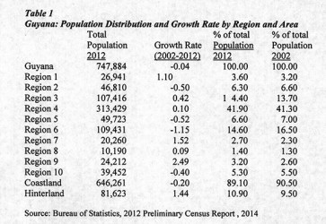
 Table 1 portrays population distribution by administrative region, geographic area, and intercensal growth rates. The information reveals that in 2012, 89 per cent of the population lived on the coastland, down from over 90 per cent, which obtained in 2002. Commensurately, the hinterland population grew from 9.5 per cent of the total in 2002 to 10.9 per cent in 2012. Population was concentrated in Region 4 (313,429 persons or 41.3 per cent of the total population); Region 6 (109,431 persons or 16.5 per cent) and Region 3 (107,416 or 13.7 per cent). The hinterland contains the sparsest populated regions (1, 7, 8, and 9) all with less than 27,000 persons.
Despite the negative national population growth rate (-0.04 per cent), the growth rate for the hinterland was positive (1.44 per cent) and for the coastland negative (-0.2 per cent). The highest positive growth rate is observed in Region 9 (2.49 per cent) and the lowest in Region 6 (-1.15 per cent).
The table reveals other useful information.
Urban-rural
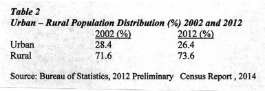
Table 2 indicates a decline in the proportion of the urban population from 28.4 per cent in 2002 to 26.4 in 2012. Contrastingly, the rural population rose from 71.6 per cent to 73.6.
The Preliminary Census information also reveals that the population proportion in urban townships has remained fairly stable over the intercensal period. There was, however, a significant decline in the absolute size of that population (down from 209,992 persons in 2002 to 191,810 in 2012). Urban population growth was -0.87 per cent. Globally, this decline in urbanisation is an outlier, reflecting natural resources exploitation in Guyana’s hinterland.
Population density
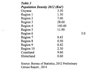
With an area of 214,999 square kilometres (km2) (83,000 square miles) and a decline in the population of 0.4 per cent, the national population density in 2012 remained quite small (3.5 persons per km2, similar to the 1980 and 2002 Censuses, and marginally larger than the 1991 Census (3.4 persons per km2).
Guyana remains geographically bifurcated. The coastland has about one-third of the land area but contains nearly nine-tenths of the population. The hinterland therefore comprises two-thirds of the land area and contains about one-tenth of the population.
Table 3 reveals the coastland has a population density of 9.6 persons per km2, which is 2.7 times the national population density (3.5 persons per km2). The hinterland area had a population density of only 0.6 persons per km2.
The Preliminary Census defines the coastland to include six regions: 2, 3, 4, 5, 6 and 10; the hinterland therefore comprises the remaining regions: 1, 7, 8 and 9.
The information by administrative region conforms to these patterns along with a few other notable features. Thus Region 4, Demerara-Mahaica, which is the site of Georgetown and its suburbs, has recorded the highest population density in 2012 (140.4 persons per km2). This was about five times larger than the region with the next highest population density (Region 3 with 28.6 persons per km2); of note, Region 5 was next (11.9 persons per km2). Further, Regions 7, 8 and 9 had a population density of less than one person per km2, with the other hinterland regions (1) having a density of just 1.3 persons per km2.
Conclusion
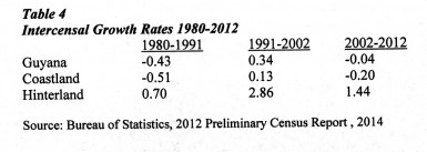
In conclusion, the data presented in Table 4 offer readers the longer perspective of three decades from which to observe the durability of the population patterns identified above. National growth rates for three intercensal periods (1980-1991, 1991-2002, 2002-2012) as well as the coastland and hinterland are shown. Significantly only the hinterland has witnessed a consistent positive growth rate over the three periods. That rate peaked at 2.86 per cent during the 1991-2002 census years.
In my view the important takeaway from this information is that deep long-lasting historical settlement patterns lie behind these data. These are so deep that, without a substantial inflow of immigrants, the population patterns revealed will persist for decades to come.
