Reports on the ground show that there is flooding in the Region Five indigenous community of Moraikobai, GINA said yesterday.
A team comprising officials from the Civil Defence Commission, the Regional Chairman of Region Five and other senior regional officials was in the community to evaluate the situation.
A day earlier, GINA had issued aerial photographs of the community taken by the Guyana Defence Force to dispel reports that there was flooding. Yesterday, GINA issued a news item reporting flooding in some parts of the community.


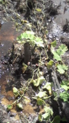
GINA said yesterday that reports are that there is severe flooding in some parts of the community, affecting mostly farmlands and crops.
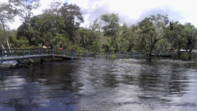
The water level in the Mahaicony River, through which the community is accessed and more so the Francois River, is extremely high.
The lower Moraikobai is the area most affected, GINA said. The effect of the flood is evident in this section of the community with farmlands under water and in those areas where the land is not flooded the soil is severely waterlogged.
However, this was not the case for Central Moraikobai which is located on a hilltop.
The rising water levels, has resulted in foot and vehicular trails becoming flooded and impassable. The trails are reportedly impassable even with the use of tractors, GINA added.
It is reported that approximately 160 families along with the farming and logging areas are affected by the flooding in Moraikobai.
The Hydrometeorological Department has projected continued rains over the next few days. Based on this projection it is likely that the residents may suffer prolonged flooding.
Recommendations have been made to the relevant agencies for the community to receive assistance especially for potable water to be supplied. Officials are monitoring the situation and attention will be paid to public health and food security matters, GINA said.
Photographs taken on Tuesday during an aerial reconnaissance failed to capture the situation on the ground, GINA said.


