Projected high volumes of traffic led to the recommendation that the East Bank-East Coast bypass road be four lanes, according to an official of the consultancy company that did the feasibility study.
Rajendra Sothwal, Senior Engineer of Indian firm RITES Limited, told Stabroek News last month that the basis for the recommendation to construct a four-lane highway linking the East Coast and the East Bank Demerara was due to the amount of traffic that they anticipate will traverse the road daily.
The firm presented their findings and recommendations at a scoping meeting held at the Critchlow Labour College last month. The Ministry of Public Infrastructure (MPI) has applied to the Environmental Protection Agency (EPA) for Environmental Authorisa-tion to execute the project. The EPA has said that an Environmental Impact Assessment is required before any decision to approve or reject a proposed project is made. Works on the road are expected to begin in the final quarter of next year.
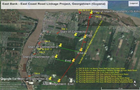
As was stated by MPI’s Technical Services Manager Nigel Erskine before, Sothwal told the meeting that the main alignment is proposed to be four-lane with four connectors; at Aubrey Barker road, Haags Bosch, Mocha Arcadia and Great Diamond. He said the total length of the entire project is around 25 kilometres with the main alignment running for 13.5 kilometres. As a result, they have also proposed that the four-lane highway’s speed limit be around 100 kilometres per hour.
When questioned about the basis for their recommendation, Sothwal told the Sunday Stabroek that it mostly had to do with the amount of traffic they project will use the road when it is completed.
According to the studies they conducted on the annual average daily traffic (AADT), using two counting stations – at MovieTowne and the Demerara Harbour Bridge – they were able to record AADT of 29,284 and 54,382 respectively. Out of those numbers; cars, jeeps and vans (which were counted as one) contributed to 19,178 AADT at the MovieTowne station and 36,283 AADT at the Demerara Harbour Bridge station.
Using that data, the company also predicted an increase in vehicular traffic from 2019 to 2029 and onwards.
According to their studies, cars, jeeps and vans will increase by 9.4% between 2019 and 2023, 9% between 2024 and 2028, and by 8% from 2029 and onwards.
For buses, which they project will increase the most, it is forecast that between 2019 and 2023, the numbers will move by 11.9%, 11% between 2024 and 2028, and by 10% from 2029 and onwards.
The road will also have four ground culverts, four steel composite bridges, intersections, sidewalks and bicycle lanes.
The consultant also said at the meeting that there will be several road safety provisions including metal beam crash barriers, concrete crash barriers, lighting, adequate traffic signs, pavement marking, impact attenuators, road studs, a pedestrian footpath, cycle track and shrub plantation in the raised median to cut headlight glare from oncoming traffic.
The project will be carried out in three stages – the detailed project report preparation, construction supervision, and post construction stage-defects liability.
The project is also expected to affect several residential properties; two at Goedverwagting, 18 at Ogle, nine on Aubrey Barker Road, 14 in Mocha and six in Diamond, which was revealed in the Environmental and Social Impact Assessment screening.
The total land area that will be acquired by the project is approximately 1,135 acres. Another scoping meeting is planned for some time next year which will also be open to the public.
Erskine had previously told Stabroek News that the works on the road are expected to being in the final quarter of next year as the preliminary report, which suggests that a four-lane highway is most feasible, was handed over in October by RITES.
He had explained that they are expecting to have the draft design report in the first quarter of this year and a month after that, the final design with the drawings and tender documents should be ready. Thereafter, it will go into bidding which will take another four to six months. By the last quarter of the year, the contractor should be mobilised and ready to start the works.
The report has estimated that the project will cost approximately US$104 million, though Erskine said the actual cost could be above or below that sum, once the project is finalised and they receive the draft design early next year.
However, Finance Minister Winston Jordan, during his 2019 budget presentation last November, had pegged the cost of the project at US$120 million.
“This by-pass, which was estimated at US$50 million a few years ago, for which funding was secured, is now projected to cost US$120 million. We will be approaching our bilateral partner to secure the additional funding to make this road a reality,” he said. India is the bilateral partner.
During the feasibility study period, which established the road alignment, Jordan said, “our engineering teams encountered a swampy area between Ogle and Diamond.”
To start preparatory works which will include draining, re-engineering and retrofitting the swamp area to facilitate the main construction works which are targeted for later in 2019, he said, $45 million has been allocated.
Jordan had explained that the frustration of road users due to the lack of an adequate road network system to meet the tremendous growth was noted, and that the bypass road is a small step in the comprehensive expansion of the country’s road network system to reduce congestion and improve travel times on the roadways.
The new road link will serve as a corridor for communities on the East Bank, including Perseverance, Mocha, Providence, Eccles, and Peter’s Hall. It will also provide a bypass from the city, where most traffic flows daily, resulting in massive congestion and major delays.


