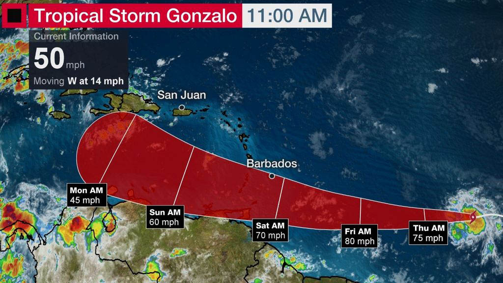
(The Weather Channel) Tropical Storm Gonzalo has formed in the Atlantic Ocean between Africa and the Lesser Antilles and could impact parts of the Windward Islands this weekend.
This system is located well over 1,000 miles east of the southern Windward Islands, moving west.
Gonzalo became the earliest seventh named tropical storm on record to form in the Atlantic basin, according to Phil Klotzbach, a tropical scientist at Colorado State University. The previous record was held by Tropical Storm Gert, which developed on July 24, 2005.
Gonzalo’s tiny size and the environment around it pose a major forecast challenge for its future intensity.Dry air is currently plentiful to the west and north of Gonzalo, which is one factor that can weaken and disrupt tropical cyclones.
While shearing winds are currently not near Gonzalo, it may encounter some modest wind shear as it nears the Windward Islands this weekend.
These factors would argue for a weakening of Gonzalo by the time it nears the Windward Islands Saturday.
However, there is an ample supply of warm, deep ocean water ahead of Gonzalo, and they’re generally warmer than average for this time of year.
Furthermore, Gonzalo is a tiny tropical storm. Small tropical storms like this can intensify quickly in the right conditions, but they can also succumb to unfavorable conditions more quickly than a larger storm. In other words, they can strengthen and weaken much more and at a faster rate than expected.
So, the range of outcomes for the intensity forecast is large, anywhere from this storm remaining weak or dissipating east of the Windward Islands, to a possible hurricane.
Fortunately, the track forecast is a bit more straightforward. We expect a general west-northwest track into the Windward Islands by Saturday, then into the eastern Caribbean Sea by Sunday.
Interests in the Lesser Antilles, including areas as far south as Trinidad and Tobago, even the northern coast of Venezuela, should monitor the progress of this Gonzalo closely.

