-Edghill says too early to know
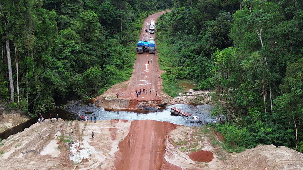
Following concerns raised by Region Nine residents and commuters, Minister of Public Works Juan Edghill says that it is too early to know if engineered creek diversions contributed to the recent washing away of a section of the Kurupukari/Lethem corridor.
“I don’t think that I can definitively pronounce on that because the water levels are too high for us to pronounce on that. So cause and water flow… we can’t at this time,” Edghill said when contacted by the Sunday Stabroek.
He noted that his ministry had dispatched a team which included Minister within the Ministry of Public Works Deodat Indar and the Chief Engineer to the area. The two had returned to the city on Friday but the remainder of the team had not, so Edghill stated he had not yet been briefed.
Residents of Region Nine as well as the operator of a bus service which plies the Lethem-to- Georgetown route told this newspaper that they believe the man-made creek diversions contributed to the washing away of the road along with government not listening to advice on what should be done.
They fear that if their advice continues to be ignored, next year would see a similar problem.
“What was the technical analysis that formed the decision for them to make the creek diversions? What flood was it designed for? Were they adequately sized? And if they were, then why this overtopping during rainfall? We told them how the creeks flow and the current and energy but no one listens…” an engineer who travels the route questioned as he spoke to the Sunday Stabroek.
“My experience aside, you don’t need to be an engineer to know that if you put bypasses and diversions, you have to get another way to effectively make up for that. When you divert creeks, it can cause flooding and landslides, sometimes not in that areas but at another point where that water should be draining. The ground will be saturated and it breaks away. Now it is flooded they will say God’s work and not because of their ignorance,’ he added.
One Lethem resident, who is also a bus driver for that route, expressed his frustration.
Landscape
“It’s the classic case of the ‘the buck-man don’t know what he is talking about’…not just this dilemma, but several other stories in Indigenous communities. Every year it is the same. We live here and know this landscape and how the rivers run and how water drains,” he lamented as he explained that last year, he also had issues with the creation of the creek diversions.
“The engineers who made this decision should face the public and explain the reasoning and say what studies they did. They should say if they consulted with people who travel that path for a living. What assessment was done? I am still waiting to see, we all are still waiting to see. It’s not like we didn’t make suggestions about this road. But in Guyana we are a reactive people… it is why we will have to be pushing buses and bush trucks in the flood for a long time,” he added.
And to support his argument, on Friday, a letter writer to this newspaper wrote that the washing away of a section of the Kurupukari/Lethem corridor is the best example of government officials ignoring local knowledge to the peril of the public, and the national treasury.
“Almost everyone who traverses that section of the road on a regular basis – and some even publicly ventilated these concerns – knew that the ‘engineering’ decision to create man-made creek channels was a foolhardy one with much implication once the heavy rains started,” the writer stated.
“… And herein is a major flaw in public infrastructure which, hopefully, the Minister of Public Works is humble enough to acknowledge. Local knowledge and input is not given enough value and importance when undertaking works in hinterland areas. And this ignoring of local knowledge is not only confined to government ministries since it is also experienced at the Regional level as well,” the writer added.
The writer posited that many times contractors “turn up to commence projects in hinterland locations without the local residents even being aware of the scope of the project or the bill of quantities. It is only when the project has commenced that locals start seeing the ‘flaws’ in the project’s concept. While some contractors are amenable to the ‘advice’ given by locals, others simply state that the project document clearly outlines what needs to be done”
“So, despite warnings from locals, the works are undertaken and within a few months remedial works are needed and the public purse is put under considerable strain.”
Thirty-six
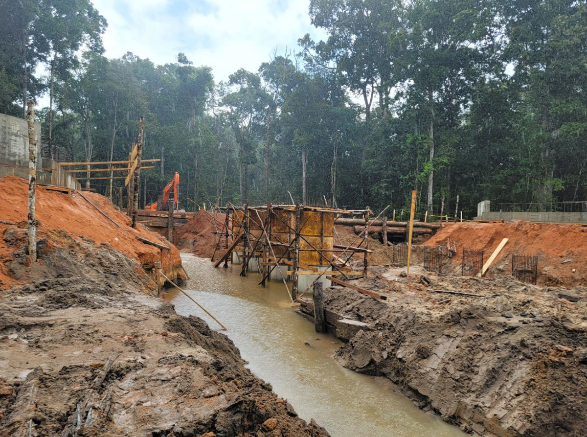
Last year April, the Public Works Ministry announced that some thirty-six concrete bridges were under construction between Kurukupari and Lethem – a project it said would improve travel on an important thoroughfare in Guyana.
The entire project had been estimated to last for eighteen months, but according to the Ministry, there had already been several delays due to unpredictable weather patterns and the finalisation of foundation designs. However, it was expected that the first phase of the project would be completed within eight to twelve months.
Although the Ministry had provided several updates, the plan to alter the flow of several creeks was never revealed. It was only after construction began that persons who traverse the Lethem-to-Linden highway noticed that the bridges were being built several feet away from the creeks along that route.
Even more surprising was that flow alterations were occurring in the Iwokrama International Rainforest Centre – a protected area in the country.
It was then that members of the public raised concerns over flow alterations occurring in and outside a protected area as a result of the project and the impact it might have on fish and the land.
“What will be the effects of these creek diversions on fishes and land?” a leader from the North Rupununi who spoke to this newspaper on the condition of anonymity, had questioned. “Did they do an assessment or hold meetings? Are we, the people, going to be affected? The fishes that we depend on? If they are doing this in a protected area, do they not need to tell us?”
The leader explicitly stated that he was not against any project that will improve the lives of hinterland residents but feels that the ministry was wrong for not disclosing such a critical detail of the project. He complained that the ministry had misled the public by claiming that they were upgrading the timber bridges when they are constructing new ones where there are no creeks or rivers.
“When they say they upgrading the bridges, we think they gone just bruk up the old one and rebuild. That is what we understand and so if we do not know what is going on, we will worry. People here [in the North Rupununi] still depend on the creeks and rivers. We do not know how we will be affected and if these creeks will change their entire course and if it will have permanent impacts.”
Stabroek News had also visited areas along the aforementioned section of the roadway last year and it was observed that contractors were indeed building the concrete bridges several feet away from the location of the creeks. The timber bridges were still in place but excavation to change the course of the creeks towards the direction of the new bridges had already begun in several areas.
One of the contractors, who asked not to be named, had told this newspaper during that visit, that once the new bridges were complete, a large area of the creeks would be filled with gravel.
When contacted, a source from the Ministry had said that the flow alterations were not a big issue because most of the creeks are seasonally filled, and the diversions were not significant to impact wildlife or the environment. Apart from changing the location of the bridges from a “strictly engineering point of view,” he said, it was done to ensure a free flow of traffic during construction while keeping road users safe as well as fast-tracking works.
He explained that there was an option to construct timber bypasses at the creeks but this would’ve been harder to maintain than the earthen bypass option that was approved instead.