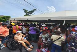
(Trinidad Guardian) Trinidad and Tobago was rocked by a magnitude 6.2 earthquake on Saturday night. Shaking was reported as far north as St. Vincent and as far south as northeastern Guyana.
According to the University of the West Indies Seismic Research Centre (UWI SRC), the preliminary magnitude 6.2 earthquake was located at 10.83°N, 62.36°W, at a depth of 45.6 kilometres, placing the quake 97 kilometres west-northwest of Port of Spain.
Shaking lasted between 30 and 35 seconds across the country, with nearly all areas across Trinidad and Tobago submitting felt reports on social media posts or to scientific agencies like the UWI SRC or the United States Geological Survey.
Following the quake, parts of northern and northwestern Trinidad, including Carenage, Santa Cruz, Goodwood, and Trinidad’s North Coast, briefly lost electricity.
There was no tsunami threat as a result of Saturday night’s earthquake, and the Pacific Tsunami Warning Center, the chief organization responsible for advising Caribbean nations on tsunami threats within the region, did not issue any statements.
For a quake to generate a tsunami, four factors need to be met: the earthquake must occur beneath the ocean or cause material to slide within or into the ocean; it must be strong, with at least a magnitude of 6.5; it must rupture the Earth’s surface and occur at a shallow depth—less than 70 kilometres below the surface; and it must cause vertical movement of the seafloor (up to several metres).
Only the shallow depth criteria were met for Saturday night’s earthquake, but the magnitude was too small.
While shaking left many remembering the last “big” quake that struck near Trinidad on August 21st, 2018, that event was far more powerful. Earthquake magnitudes are logarithmic, meaning the larger the magnitude, the more energy is released, and the duration of shaking is longer.
In 2018, the earthquake registered a magnitude of 6.9 on the Richter Scale, with shaking lasting 90 seconds. Saturday night’s quake was a preliminary magnitude 6.2, with shaking lasting between 30 and 35 seconds. Though the difference in magnitude was 0.7, the 2018 earthquake was five times bigger and released 11 times more energy, which resulted in damage across parts of Trinidad.
Ultimately, the northwest of Trinidad is a very seismically active area that has produced earthquakes registering above magnitude 7.0 in the past. In fact, based on records from the UWI SRC, over 2,400 earthquakes have been recorded in the area since 1960. Within the last three months, the UWI SRC has recorded 13 earthquakes above magnitude 3.5 northwest of Trinidad.
Hence, as we live in an area where earthquakes are always occurring, it is always important to know what to do when the “big” one hits: drop, cover and hold under a sturdy table or desk.